|
Serengeti is situated
West of Great Rift Valley, 130km west-north-west of Arusha.
A corridor extends westwards to within 8km of Lake Victoria
and a northern sector extending to the Kenya border. In
Mara, Arusha, and Shinyanga regions. 1�30'-3�20'S, 34�00'-35�15'E.
The park has been a
Protected area since 1940. In 1929, 228,600ha of central
Serengeti was declared a game reserve. Afforded national
park status in 1951 with extensive boundary modifications in
1959. Internationally recognised as part of Serengeti-Ngorongoro
Biosphere Reserve (with the adjoining Maswa Game Reserve)
under UNESCO's Man and the Biosphere Programme in 1981 and
inscribed on the World Heritage List in the same year.
Serengeti National Park
(1,476,300ha) is contained by the biosphere reserve
(2,305,100ha); contiguous to Ngorongoro Conservation Area
(809,440ha) in the south east, Lolindo Game Controlled Area
to the north east (400,000); Maswa Game Reserve (220,000ha;
recently reduced) in the south, Maasai-Mara National Reserve
(151,000ha) in Kenya to the north, and the Ikorongo-Grumeti
Game Controlled Area (500,000) in the west.
The plains of Serengeti are
mainly crystalline rocks overlain by volcanic ash with
numerous granitic rock outcrops (kopjes). In the north and
along the western corridor are mountain ranges of mainly
volcanic origin. Two rivers flowing west usually contain
water and there are a number of lakes, marshes, and
waterholes.
Rainfall is mainly
restricted to November-May with peaks in December and
March/April. Mean annual temperature 20.8�C and mean annual
precipitation 1210mm recorded at 1,150m. Rainfall tends to
decrease towards the east and increase to the north andwest,
reaching 950mm annually in the western corridor near to Lake
Victoria, and 1150mm annually in the extreme north of the
park near to the border with Kenya.
The undulating open
grassland plains are the major type of vegetation, but
become almost desert during periods of severe drought.
Dominant species are couch grass Digitaria macroblephara
and Sporobolus marginatus (an indicator of saline
soils). In wetter areas, sedges such as Kyllinga spp.
take over. There is an extensive block of acacia woodland
savanna in the centre, a more hilly and densely wooded zone
covering most of the northern arm of the park, and some
gallery forest. Lowland woodlands comprise Commiphora,
Acacia drepanolobium, and A. gerrardii. Upland
woodlands comprise Acacia lahai and A. seyal.
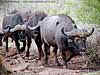
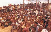
The park is best known for
the now unrivalled herd sizes of 'plains game', which
migrate between seasonal water supplies and grasslands.
These include wildebeest Connochaetes taurinus (LR),
zebra Equus burchelli, Thomson's gazelle Gazella
thomsoni (LR), numerous prides of lion Panthera leo (VU)
numbering up to 3,000 individuals (Packer, 1996), and
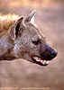
spotted hyena Crocuta crocuta (LR). In May and June
many game animals take part in a mass migration away from
the central plains into the western corridor. The annual
wildebeest migration is described in SRCS (1992) and Murray
(1992). In the 1950s the wildebeest population is thought to
have numbered 190,000, subsequently increasing to an
estimated 1.69 million in 1989 (SRCS, 1992), and 1.27
million in 1991 (TWCM, 1992). Other characteristic mammals
are leopard Panthera pardus, cheetah Acinonyx
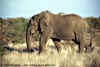
jubatus (VU), elephant Loxodonta africana (EN)
estimated to number 1,357 in 1994 (Said et al.,
1995), black rhinoceros Diceros bicornis (CR),
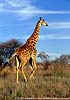
hippopotamus Hippopotamus amphibius, giraffe Giraffa
camelopardalis (LR), buffalo Syncerus caffer (LR),
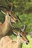
topi Damaliscus lunatus (LR), waterbuck Kobus
ellipsiprymnus (LR), eland Taurotragus oryx,
sitatunga Tragelaphus spekei (LR), bushbuck T.
scriptus, oryx Oryx gazella (LR), reedbuck Redunca
redunca (LR), mountain reedbuck R. fulvorufula (LR),
numerous species of rodents and bats, golden jackal Canis
aureus, side striped jackal C. adustus, Grant's
gazelle Gazella granti (LR), seven species of
mongoose, two species of otter, warthog Phacochoerus
aethiopicus, and seven species of primate. Smaller
predators include bat-eared fox Otocyon megalotis and
ratel Mellivora capensis. The last packs of wild dog Lycaon
pictus (EN) disappeared from the park in 1991. A rabies
epidemic killed three of the packs, but there is no clear
consensus on the full cause of the disappearance (Morell,
1995; Dye, 1996; East and Hofer, 1996).
Over 350 recorded bird
species include 34 species of raptors, six vultures, kori
bustard Choriotis kori, ostrich Struthio camelus
and lesser flamingo Phoenicopterus minor (LR), and
several with a comparatively restricted distribution such as
rufous-tailed weaver Histurgops ruficauda.
The park has been the
centre for major research for the past 30 years. The
Serengeti Wildlife Research Institute (SWRI) has a research
centre at Seronera. This has well-equipped laboratories, a
library, herbarium and accommodation for visiting
scientists. Projects active during 1992 included the
continuation of long-term research on ecosystem processes,
the behavioural ecology of lion, leopard and ungulates,
population dynamics and reproduction of mongoose, and the
ecology of dung beetles and termites. A programme on the
behaviour and ecology of the African wild dog used
radio-collaring techniques to monitor 22 individuals (SWRC,
1993). When the wild dog population disappeared from the
park in 1991, controversy erupted over whether the stress of
handling the dogs to fit radio-collars helped cause their
disappearance (Morell, 1995; Dye, 1996; East and Hofer,
1996). A number of externally funded scientists conduct
research at the SWRI, and the staff of the Tanzania Wildlife
Conservation Monitoring (TWCM) programme have taken over the
long term ecological monitoring programme, and carry out
regular aerial surveys and wildlife censuses (SRCS, 1992).
Serengeti National Park,
with its herds of ungulates and their associated predators,
is the last remnant of a Pleistocene large mammal ecosystem
in all its complexity. The park, in combination with the
contiguous Ngorongoro Conservation Area and Maasai Mara
National Park, is sufficiently large to ensure the survival
of this savanna ecosystem.
Olduvai Gorge is an archaeological site located in the
eastern Serengeti Plains, which is in northern Tanzania. The
gorge is a very steep sided ravine roughly 30 miles long and
295 ft. deep. Exposed deposits show rich fossil fauna, many
hominid remains and items belonging to the one of the oldest
stone tool technologies, called Olduwan. The time span of
the objects recovered date from 2,100,000 to 15,000 years
ago.
The main Olduvai Beds are in a lake basin about 16 miles
in diameter. The rocks under the basin date to 5.3 million
years ago. There have been seven major Beds distinguished
they are ranked from oldest to youngest; Bed I, Bed II, Bed
III, Bed IV, the Masek Beds, the Ndutu Beds, and Baisiusiu
Beds.
Bed I dates to 2,100,000 years old and is 197 feet thick.
It is mainly formed of lava flows, volcanic-ash deposits and
other sediments. The upper part of the bed contains varied
fauna and evidence of the Olduwan industry. Skeletal remains
of hominids are assigned to the Homo Habilis an
Australopithecus Boisei families. Campsites and what is
believed to be a butchery site have also been excavated from
this bed.
The Hominid living sites in Bed I are found mainly where
streams from the volcanic highlands carried fresh water to
Olduvai lake. The conditions for the preservation of the
sites is mainly due to the ash falls from the nearby
volcanoes and the inconsistency of the lake's depth. The
debris found at the sites are various Olduwan tools, bone
and teeth from animals, mainly from fair sized antelopes.
Also a loosely built circle of lava blocks was found,
suggesting that crude shelters were formed here as well.
The living sites in Beds II-IV are normally found in what
would have been river and stream channels. Therefore, many
of the sites were displaced by water action.
Bed II is 66-98 feet thick and is 1,150,000 to 1,700,000
years old. It has two main divisions of rock layer, upper
and lower, that were separated by an erosional break. The
lower part of Bed II is similar to Bed I. The upper part was
formed after fault shifts had reduced the ancient lakes
size. It is in this part of Bed II that the development of
the Acheulian industry starts to show. Here also are the
remains of Homo Habilis, Homo Erectus and Australopithecus
Boisei.
The gorge was modified by fault shifting and erosion. It
is after these geographical changes that Beds III and IV
were created. These two Beds range from 1,150,00 to 600,000
years ago. These two Beds are separable only in the eastern
part of the gorge and are combined elsewhere into a single
unit. They have a maximum thickness of about 98 feet and
consists mainly of sediment from streams that fed Olduvai
Lake.
During a period of major faulting and volcanism roughly
400,000 to 600,000 years ago, the Masek Beds accumulated.
They are up to 82 ft. thick and again contain mostly stream
sediments with some aeolian (wind-worked) tuff. It is
assumed the climate at this time was probably much like
today based on the deposits found there. There is only one
major archaeological site found in these beds and it is of
the Acheulian tool industry.
The Ndutu Beds were formed by faulting, erosion and the
filling of the gorge around 32,000 years ago. It consists
mainly of aeolian tuff. In this Bed two sites have been
found which date to the Middle Stone Age.
The last of the archaeological Beds is the Naisiusiu. It
lays in the bottom of the Gorge at what is now the present
depth. It only has a depth of 33 ft and also consists of
aeolian tuff. It contains one site that has microlithic
tools and one complete Homo Sapien skeleton, both of which
date to 17,000 years ago.
To
visit Serengeti, please talk to our staff below.
Mrs
Maggie Mlengeya (Managing Director)
Email:
serengetiso@yahoo.com
Tel
255-27-253 7095 OR Cell
255-748-40 6996
Or
Rafiki
Africa, New Mwanza Hotel.
Tel
255-28- 49040 OR Cell
255-748- 32 1180
Email:
rafikiafrika@yahoo.com
Or
Kirstin
Lightfoot,
567
SE Shoemaker Place, Pullman,
WA 99163, USA.
Tel
509-339-24-9, Email: kirstin@vetmed.wsu.edu
|